Chance favors the connected mind.
-Stephen Johnson
So I had this idea. Perhaps it’s more appropriate to say “we” had this idea. More about that below. About 40 seconds into this video, it hit me: use quadcopters to gather high resolution images that can be used by students in the Geosciences.
Let me take a step back.
For a couple of years now, Jason Pittman (professor of Geosciences) and I have been collaborating on and developing prototypes of mapping projects. Originally inspired by Google Lit Trips, over the course of several semesters Jason has developed and refined activities and assignments for his students – see The Subterranean Landscapes of Downtown Sacramento, Alternative Energy in Sacramento County, Salmon Life Cycle and the Effects of Anthropogenic Alterations to Habitat and Mining in El Dorado County.
Meanwhile, Gary Hartley (Dean, Instruction and Technology), has been wrapping up a multi-year grant called CPATH. In a nutshell…
CPATH is concerned with Computational Thinking – a way of describing problems and devising solutions that can effectively utilize the power of computers and computing
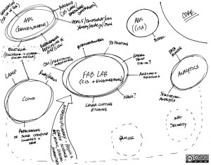
Additional information about CPATH can be found here. I’ve been in conversations lately with Gary about the successor grant, and multi-year, multi-dollar affair NSF grant called Computing Education for the 21st Century, or CE21. You can read about it here.  The content of those conversations, which also involved Stu Van Horn (Dean, Instruction and Careers and Technical Education) had to do with re-imagining CIS at Folsom Lake College. Over there is a little cocktail napkin drawing that I devised to frame the conversation. I’d love to see the college move toward a DIY, hardware hacking ethos, with iRobot Roombas tooling around the college building 3D maps using Microsoft Kinect sensors, and all kinds of fabrication and Makerbots and lasers and Arduinos and that sort of thing. An interdisciplinary, maker/hacker/tinkerer sort of program. Applied computing and engineering and art and GIS and music and biology and everything else. Blinking lights and whirring sounds and the sharp smell of ozone – that’s what learning should be like. Perhaps one day the college will get there.
In any case, a month or so ago, a student named Dave approached me about starting a robotics club at FLC. He’s working on the charter as of this writing, and I will serve as one of the faculty advisors. About that same time, I became aware of a local organization called Dweeb Den, a collection of folks attempting to establish a hackerspace in Sacramento.
On Saturday, February 18th, 2012, I attended the Dweeb Den kickoff meeting. The meeting took place in a conference room at Parallax, a local company that makes microcontrollers and robotics kits. The meeting concluded with a demonstration of Parallax’s ELEV-8 quadcopter platform. Equipped with a GoPro camera, the quadcopter flew around the parking lot, then soared high into the air. A week later, the Dweeb Den folks posted the video of the quadcopters flight, and at ~40 seconds into the video, it all hit me like a bolt of lightning.
As if consumed by fever, I quickly drafted a proposal and budget, and working with Jason and Gary and Stu, we were able to find funding for a prototype. The project will help FLC students develop technical geospatial analysis skills and learn contemporary applications of geospatial imaging, and the images will be used for spatial analysis; evaluating landscape changes, hazard analyses, and investigating rural and urban development.
Requisitions are moving through the system now. I want to document as much as I can about the project, about successes and failures, hurdles and challenges and red tape and process. It is my hope that, should the project prove successful, others might find the information here that they need to engage in similar projects, or better yet, that they might extend and adapt the idea. The contents of this blog, and all images, documents and writings contained herein are licensed under a CC BY-NC-SA license. Go forth and share.
TL;DR We’re going to put cameras on quadcopters and take pictures for students studying Geosciences to use.
